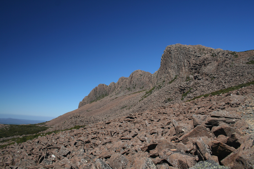
Ben Lomond National Park is a dramatic rocky plateau that reaches up above the tree-line. There are large boulder fields covering the slopes that are the remnants of a glacier that once covered the area. It is home to the 2nd tallest peak in the State, Legges Tor. The area is accessable by either car or on foot.
Special Photographic Features or Notes.
The dolerite peaks surrounded by the glacial block-fields make for some spectacular scenery that is unlike anything I have seen elsewhere in the country. Almost all of the National Park is above the snow-line in Winter which together with the rocky terrain makes for a somewhat desolate but beautiful landscape. In the winter the park is home to a downhill ski resort and there is a pub that is open all year in the alpine village.
You can drive to the village via the narrow road that winds its way to the top of the mountain. The road has recently been improved making it safer particularly around the area known as Jacobs Ladder. If you start your walk from the village there is a bushwalkers book to indicate where you walking and your expected return time.
The other option to access the peaks is from Carr Villa which is about 1km inside the park boundary. There is a well defined trail starting here although there is no intentions book at this location. The trail crosses the block-fields and climbs steeply up onto the plateau. Once you reach the top the walking is relatively flat with the occassional gentle climb. The trail is marked with snow poles along its entire length. About half-way along the track you’ll walk past the remnants of an early ski hut, not much remains aside from some corrugated iron.
<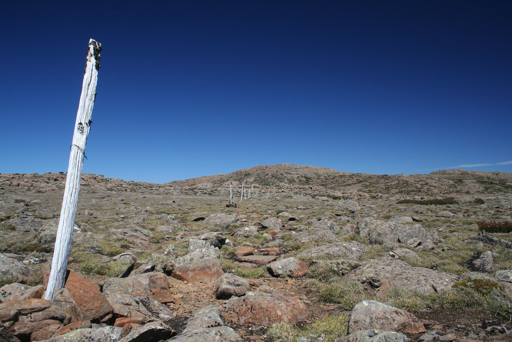
This part of the park is known as the “Field of Mars” and it is easy to see why. The track eventually passes a number of huts that belong to different alpine clubs. From there you’ll be able to see the ski lifts and the summit of legges tor. The summit is marked by an impressive stone tor. You can easily walk to the top of Giblin Peak as well although you may need to do a bit of boulder hopping. You can either walk back the way that you came or return via the road to Carr Villa. The Tasmanian Parks & Wildlife Service have rough maps of the park including these tracks on their website at Ben Lomond National Park & Alpine Village.
The plateau is quite open and it would appear quite easy to walk to other peaks in the area as a result. The guide books warn against leaving the trails unless you are an experienced bushwalker who is confident and capable at navagation. It is very easy to become disoriented if the fog closes in and all of a sudden one rock looks very much the same as the next.
Night Photography.
This area is unaffected by light pollution and would be a great spot for star-trails. There are 6 camp-sites located just outside the park but these are surrounded by tall trees which block the sky. The alternative is to camp in the National Park itself but to do that you must be at least 500 metres away from any roads.
Special Equipment.
You need to be prepared for rapidly changing weather conditions because like much of Tasmania the weather can close in very quickly. The plateau is very exposed but the trail itself is reasonably well marked. Let somebody know where you are and when you expect to return. In winter the road into the park is affected by snow and ice, if the road is open you require snow chains or there is a bus that runs to the village during the ski season.
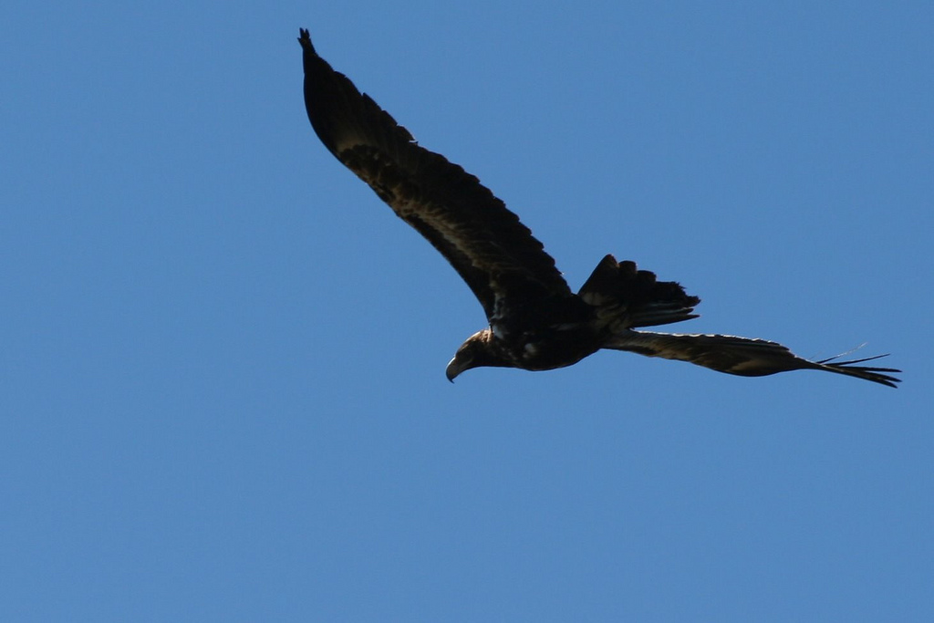
I’d recommend a circular polarizer and a wide angle lense but you will find something to photograph up here no matter what you choose to take. Despite the lack of any signifigant vegetation there are lots of interesting wild-flowers and lichen growing on the rock. I saw a couple of wallabies and the signs that wombats are about. The highlight of my time in the area was a wedge-tail eagle that came gliding over the crest of the hill behind me. It was only about 20 metres above me at the time but as murphys law would have it I had a macro lense on at the time.
Best Time of the Day.
This is a location in my opinion where good photographs can be found at anytime of the day depending on the weather conditions.
Getting There.
From Launceston follow the Tasman Highway A3 for a short distance until it reaches St Leonards Road C401. Follow this for approximately 45 km after it becomes Blessington Road. About 3 1/2 kilometres before the township of Upper Blessington you will reach Ben Lomond Road. (Google Map) A couple of kilometres up this road you’ll reach a small number of campsites. You can camp here for free, there is a flush toilet and water available. There is a view back out across the valley from here. Driving further up Ben Lomond Road will bring you to Carr Villa which is a couple of kilometres into the National Park. If you continue to follow the road for a couple of kilometres you’ll reach the alpine village. (Second Google Map).


